The Weather Thread

I don't know how hurricane prediction works, but is it possible to predict a probable intensity?
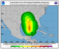
Yes. NOAA provide some very informative graphics about this.

1591363801970.png

In the centre of that blob there's a 50-60% probability of tropical storm force winds (39-73 mph) over the next 5 days. A similar graphic gives zero probability of hurricane force winds (>74 mph) over the same time period.

The images I've posted previously with the cones have black circles showing what type of cyclone the system currently is and is expected to be, i.e. D for Depression, S for Storm, H for Hurricane and M for Major Hurricane (>110 mph winds).
 
If I understand it correctly, a tropical storm is not identical to a tropical cyclone, but the latter is an overarching category including both hurricanes and tropical storms?
 
Correct.

All tropical storms are tropical cyclones, but not all tropical cyclones are tropical storms. :) This is the US definition for Atlantic, East Pacific and probably Central Pacific tropical cyclones. Australia, Japan, India, Philippines etc. all have different terminologies for these systems.
 
If I understand it correctly, a tropical storm is not identical to a tropical cyclone, but the latter is an overarching category including both hurricanes and tropical storms?

From what I've seen hurricanes are a U.S thing, cyclones are Australian and East Asia has Typhoons.
 
I think cyclone is the general term for this type of storm, be they hurricanes, typhoons, willy-willies or tropical storms.
 
From what I've seen hurricanes are a U.S thing, cyclones are Australian and East Asia has Typhoons.
All of these are cyclones, but Australia doesn't have another word for them. Typhoon and hurricane are words specific to the regions in which they're used, although hurricane is the most commonly used word globally because of US media saturation.

And FYI, a cyclone is a weather system which rotates, er, cyclonically around a low pressure centre and air at the surface is converged towards the centre and then rises. In the northern hemisphere they rotate anti-clockwise and in the southern hemisphere they rotate clockwise (the wrong way).
 
I'm going to be 40 km to the east of Tallinn tomorrow and many more days with 13° while less than 200 km away on the Russian border, Narva will enjoy a nice 25 degrees. :facepalm:

Edit: from Narva to St. Petersburg is only a 150 km drive. I never realised it was so close.
 

This was 2 years ago, last time we got hit by a big storm. Never seen it happen here. Whole cellar was flooded
 
Back
Top